The main drivers of change in the forest ecosystems in Europe are forest activities. Change detection using a long time series of optical satellite imagery with relatively high resolution enables annual detection of changes with high accuracy.
Therefore, in order to provide fine spatial resolution information and support the calculation of statistically rigorous estimates about the extent condition and pressures on the forest ecosystems, a framework for an RS-based forest ecological base map has been presented by our partners of NMBU.
The framework was used to create the first version of a forest ecological base map for Norway which establishes model-based estimates at a local level to support indicator development of forest condition and pressures on a detailed geographical level. The more specific aims of the work are as follows
- Mapping selected forest attributes describing ecosystem condition, i.e. biomass, volume, height, density (number of trees), crown cover.
- Evaluating ALS as a source of providing information about forest
naturalness. - Evaluating a methodology to detect and classify pressures on the
forest ecosystems in terms of permanent (land-use changes) or temporary changes (harvests). - Providing estimates with associated uncertainties on an aggregated local level from the detailed maps, i.e., fine spatial resolution maps.
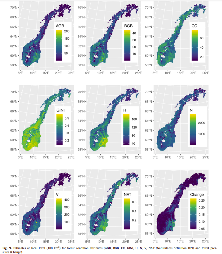
As a part of the result, the estimates of forest condition and pressure at the 100 km2 blocks are presented in the following fig which provides new insights into how the forest condition and pressures are distributed geographically. Areas with large AGB and V density appear in the same locations and are independent of, e.g. H. The GINI index was smaller in the most actively managed forest areas.
Many of these attributes can be predicted and estimated using the same framework and data as described here. The framework can also be adapted and used in other countries having high-quality forest information on accurately geolocated sample plots and available remotely sensed data.
To learn more about this precious finding please find the full article written by Hans Ole Ørka, Marie-Claude Jutras-Perreault, Erik Næsset, Terje Gobakken in the link below: https://www.sciencedirect.com/science/article/pii/S1470160X22001078